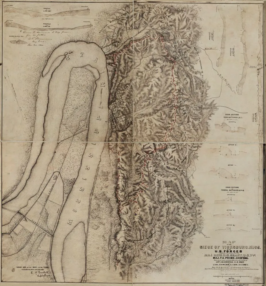
Map of the Siege of Vicksburg, Miss.
Historical map of the Siege of Vickburg
By the U.S. Forces under the command of Major General U. S. Grant
Maj. F. E. Prime, Chief Engr. : surveyed and constructed under direction of Capt. C. B. Comstock, U.S. Engrs. and Lt. Col. Js. H. Wilson, A. I. Genl., 1st Lt. Engrs. : by Major Otto H. Matz, Ills. Vols., Chs. Spangenberg, Asst. Engr., Lts Patton, Karnasch & Helmle, Mo. Vols., Lzwanziger, S.R. Tresiliean, B. Barth, S. Hartwell, Asst. Engs. : drawn by Chs. Spangenberg, Asst. Engr., Head Qrs. of the Dept. of the Tenn., Aug. 20th, 1863.
Spangenberg, Charles.
[Vicksburg, Miss., Head Qrs. of the Dept. of the Tenn., 1863]
Relief shown by hachures.
Reference: LC Civil War Maps (2nd ed.), S120, 285
Dedicated in ms: To Thomas E. Sherman to keep forever, from his father, W.T. Sherman, Maj. Genl. Jan 20, 1864.
Union and Confederate entrenchments are hand colored blue and red respectively.
Detailed map showing roads, streets, railroads, hachures, vegetation, houses, and drainage.
Contains five topographic profiles, six cross sections of artillery batteries, and one cross section of a "rebel rifle pit."
LC copy inscribed at bottom: Cha Sangenberg, , Asst Engr.
Scale [ca. 16,800]. (not "four inches to one mile").
Library of Congress Geography and Map Division Washington, D.C. 20540-4650
Learn More: The Siege of Vicksburg