Antietam | S.G. Elliott Map Section | The Final Assault
A portion of the S. G. Elliott Burial Map for the Antietam Battlefield—Final Assault Sector
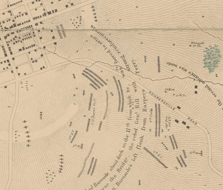
Once Maj. Gen. Ambrose Burnside’s IX Corps captured the lower bridge (today known as the Burnside Bridge), his men took nearly two hours to cross it and form for an attack against the final Confederate line. Finally, at about 3:00 pm, a mile-wide battle line of Union soldiers swept forward across the rolling terrain. About 2,500 Confederate soldiers with artillery awaited them on the high ridge south of Sharpsburg. The fighting was intense as Burnside’s men neared the road to Boteler’s Ford in Lee’s rear. The 9th New York Infantry, also known as “Hawkins’ Zouaves,” suffered 63% casualties on the outskirts of Sharpsburg. Just then, exhausted after marching 17 miles from Harpers Ferry, Gen. A.P. Hill's Confederate "Light Division" slammed into the exposed Union left flank and drove the Federals back. The brand new 16th Connecticut Infantry, barely two weeks old, bore the brunt of Hill’s attack, some of them had not learned how to load their muskets until the day before. Divisions of the V Corps remained in reserve and were not moved forward to support Burnside. The timely arrival of Hill, and the failure of McClellan to support Burnside's final assault ultimately saved General Robert E. Lee and his Army of Northern Virginia.
This section of the Elliott Antietam Burial Map shows the sector of the final Federal assault at Antietam. Near the top left corner of the map, you will notice an artillery line with many dead horses behind the guns. This is the area of the modern Antietam National Cemetery which was established in 1865. Upon examining the map in this sector, you will notice the disproportionate number of Union to Confederate burials. Approximately 495 human and 17 horse burials are represented in this section of the map as well as 17 artillery pieces.
The map is housed in the collection of the New York Public Library, and you can download a high-resolution copy of the map from their website.
Learn More: Nineteenth-Century Geolocation: The Elliott Map of Antietam | Battle of Antietam

Related Battles
12,401
10,316


