In the popular imagination, archaeological work is centered in the field, physically digging in the dirt. Such a picture, however, is both inaccurate and incomplete. Modern techniques have eliminated excessive disturbance of historic landscapes, instead gathering data through noninvasive means and limiting excavation and artifact retrieval to highly targeted areas. Moreover, the work of the archaeologist hardly ceases at the conclusion of the dig, as cleaning and cataloguing of recovered items and data analysis may extend for many months.
AVAR strives to ensure participants get exposure to the curation and lab work of archaeology, as well as the excavation and survey components of the process, with teams rotating between them. At Saratoga, AVAR volunteers worked alongside NPS archaeologists and curators to process, clean and document the artifacts uncovered during earlier phases of the project.
“The first part of the process is identification, which includes describing material, weight and measurements,” said Park Service archaeologist Joel Dukes, who is working on the analysis from his office based at the Boott Cotton Mills Museum in Lowell, Mass. “From this, we separate items that are battle-related — musket ball, case shot, uniform buttons — from those that represent the multiple domestic occupations of the site, like nails and utensils.
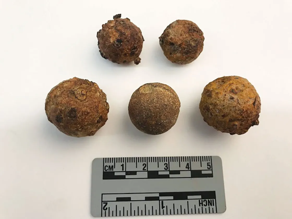
Each artifact type receives different types of analysis. Take musket balls, which are classified as either dropped — which can indicate troop positions — or fired. Researchers identify musket-ball caliber to help associate them with specific weapons carried by the different forces on the field. External impact marks and dents can identify what a musket ball struck after it was fired. Impacted balls will also be catalogued against the degree of deformation using a Lead Bullet Deformation Index developed based on experiments with colonial firearms, which has proven a correlation between muzzle velocity and degree of bullet deformation, providing insight into the distance traveled by recovered bullets.
“We want to answer the question: Do recoverable artifact patterns survive that reflect the actions and specific events that produced them on the field of battle? Using geographic information systems, we will combine the artifact data with the GPS points that we collected during recovery and overlay them on the aerial views … to provide a visual representation of artifact distribution across the landscape,” said Dukes. “The distribution of case shot across the site already looks promising for helping us triangulate back to the potential placement of the German 12-pound guns.”
Final reporting on the Saratoga project will not be available for some time, but to mark Independence Day 2019, NPS’s Northeast Region Archeology Program offered a sneak peak of the findings on its Facebook page:
“October 7th, 1777 British and Allied German forces led a scouting mission to determine if they should attack nearby Continental troops. They advanced to a structure in a wheat field on the Barber Farm. American troops noticed their approach and preceded to attack, soon overwhelming the British and German troops and gaining a decisive victory.
“According to written reports, such as the one by General George Pausch of the German artillery, there were both 12 and 6 pound cannons in the field and near the structure. The General had to abandon these cannons when he was pushed back by Continental troops.
“Although Saratoga National Historical Site has long known the general location of the Barber Wheatfield, until recently, there was no way to know the exact location of the forces, the structure, and the cannons.
“This summer’s survey aimed to change that. One of the goals was to learn more about movements on the field and the lay out of the battle — including the location of the cannons. During the survey at Saratoga, dozens of case shot (small iron balls placed in a canister) were recovered. The location of a recovered shot was determined using a GPS, and the spot was recorded on a map.
“After the field was completely surveyed, archeologists noticed two overlapping patterns fanned out in an almost baseball diamond shape. One pattern was for the 12 pounder case shot and one pattern was for the smaller 6 pounder case shot. Following the patterns to the points (near home plate), archeologists calculated the location of those cannons that tried unsuccessfully to stop the Continental troops!”