The Terrain and Fortifications of Harpers Ferry
Earl J. Hess
Harpers Ferry, an old and important arsenal town at the confluence of the Potomac River and the Shenandoah River, was nestled among some of the most imposing mountains to be found in the eastern United States. The Potomac River was the only stream powerful enough to cut through the uplift as plate tectonics created the mountains millions of years ago. Thus the gap at Harpers Ferry is the only deep water gap in the Blue Ridge. The flow of the Shenandoah River, the largest tributary of the Potomac, was diverted when the Blue Ridge rose up. All other smaller streams in the area also were redirected by the rise of the mountains to flow into the Shenandoah or the Potomac, leaving many so-called wind gaps in the mountain tops. They are the remnants of stream erosion, cut slightly into the emerging mountain top before the water was diverted. The combination of plate movement and hydrography created a rugged, natural arena with the town of Harpers Ferry as the stage.
The most important high ground is Maryland Heights, actually part of the Blue Ridge. The heights are the end of a long, wide, and high ridge that stretches many miles from the north. The elevation of Maryland Heights ranges from 1,300 to 1,400 feet, almost 1,000 feet higher than the land beside it. The end of Maryland Heights points directly toward the junction of the two rivers. On the other side of that junction, the Blue Ridge continues with Loudoun Heights, which constitutes the modern boundary between Virginia and West Virginia. West of Harpers Ferry, Bolivar Heights is a ridge some 700 feet tall, about 300 feet higher than the town itself. Bolivar Heights is a superb defensive position screening the western approach to Harpers Ferry. All this high ground surrounding the town could be converted into good defensive positions if adequately fortified and manned, but that would require thousands of troops. If left unguarded, the high ground on each of the three sides could doom the town by allowing enemy forces to dominate Harpers Ferry with artillery fire.
The mountain tops had a thick layer of original trees until the 1840s, when local residents extensively cut it to produce charcoal. By the time of the Civil War the heights were covered by a second growth of scrubby timber and underbrush. Virginia militiamen under Colonel Thomas J. “Stonewall” Jackson occupied Harpers Ferry in April 1861, and 500 of them took possession of Maryland Heights on May 9. They cleared an area on top and erected a stockade, but Confederate Brigadier General Joseph E. Johnston evacuated Harpers Ferry in mid-June, 1861. Union Captain John Newton scouted the heights when the Federals took possession and reported that the vegetation was so thick as to be “difficult of penetration.” This led Federal commanders to defer extensive fortification on the high ground, but they could hardly ignore the strategic significance of the heights. When Jackson’s Valley campaign was in full swing in May, 1862, Federal engineers hastily laid out the Naval Battery, manned by gunners from the Washington Navy Yard. It was located on a plateau one third of the way up Maryland Heights and could fire on almost any spot in town as well as on Bolivar Heights. It had seven gun emplacements and the parapet was made mostly of sandbags. A road that had been made before the war by charcoal and quarry workers was used to gain access to the site, some 400 feet above the Potomac.
The Capture of Harpers Ferry
By September, 1862, when Stonewall Jackson advanced on Harpers Ferry, the post was ill-prepared to meet him. Union Colonel Dixon S. Miles had commanded the place since March, but had done little to fortify it beyond constructing the Naval Battery. Under pressure from department commander Major General John E. Wool, Miles also erected a line of infantry trench on Camp Hill, a modest elevation between Bolivar Heights and the town. Wool’s instructions to build a blockhouse on Maryland Heights, lay abatis in front of the work on Camp Hill, and entrench a camp on Bolivar Heights, were never followed.
Miles had 11,000 men at Harpers Ferry but most were green troops who had never been tested in battle. As the three Confederate columns converged on the place, Brigadier General Julius White brought an additional 2,500 men from Martinsburg on September 12. Although White outranked Miles, he gave up command of the post and its threatened garrison to the colonel.
The faulty dispositions of this incompetent officer gave Jackson his opportunity to seize the heights. Miles put three of his four brigades west of town, two on Bolivar Heights, and another on Camp Hill to support a battery of fourteen guns. The last brigade, under Colonel Thomas Ford, was placed in an isolated position on Maryland Heights. Ford constructed a line of breastworks consisting of logs and rocks, and cut trees to form an abatis in front. Loudoun Heights was left unoccupied.
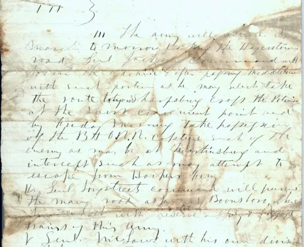
On September 12, the day that White reached Harpers Ferry, a Confederate column under Major General Lafayette McLaws ascended Maryland Heights and advanced to Ford’s line of breastworks by nightfall. McLaws outflanked the line the next morning and compelled the Federals to retreat. Ford apparently misunderstood an order from Miles and took his entire brigade off Maryland Heights that afternoon.
As McLaws achieved this easy victory on September 13, two other Confederate columns approached Bolivar Heights and Loudoun Heights. Jackson’s column blocked Union escape on the west and Brigadier General John G. Walker’s column began to ascend Loudoun Heights as McLaws planted six guns on Maryland Heights. Walker’s command found the summit of Loudoun Heights unoccupied and constructed emplacements for five guns on September 14. Jackson established his batteries on School House Ridge, a lower but well defined feature about 1,000 yards in front of Bolivar Heights.
Confederate artillerymen dominated the poorly placed Union guns when they opened fire on the afternoon of September 14, but the Federal infantry was well protected by ravines and suffered comparatively little. While the guns roared, Major General A. P. Hill’s division found an opening on the south end of Bolivar Heights. A shelf of bottomland along the river allowed him to flank the Union forces on the high ground and plant some guns in preparation for an attack the next day. Only a line of abatis stood in Hill’s way.
Fifty Confederate cannon resumed the bombardment of Harpers Ferry on the morning of September 15. Soon the Federal guns ran out of long range ammunition and Miles surrendered. White flags were raised but one of the last Confederate shells mortally wounded Miles. White now assumed command and negotiated the surrender. Jackson captured 12,500 men and seventy-three guns, but lost only 286 men. Only 217 Unionists were killed and wounded. The Northerners were outnumbered, inadequately fortified, and ineptly led, and their loss of supplies and prestige was enormous.
Defenses of Harpers Ferry
The Federals returned to Harpers Ferry soon after the Battle of Antietam. The post had demonstrated its strategic usefulness by hindering Lee’s communications during the campaign, and now a major effort was made to erect the kind of works that would secure the post against a large attack such as the one Jackson had unleashed.
Engineer Lieutenant Cyrus B. Comstock surveyed the area in early October, 1862, and recommended that a lot of work be done, but his recommendations fell short of what actually was needed to secure the post. Comstock correctly noted that holding the peninsula west of the junction of the Shenandoah and Potomac was the key, and he recommended extensive earthwork construction to guard against an attack from the west. Bolivar Heights should be fortified with a line nearly two miles long, consisting of an infantry trench and three battery emplacements. The heights should be held by 6,000 men and twenty-seven guns. Comstock wanted the line placed a bit down the forward slope of the height and continued all the way to the Shenandoah, where a redoubt would be constructed on the bottomland. This was to prevent the enemy from flanking the line as A. P. Hill had done the previous month. Comstock also recommended the construction of a redoubt on a hill north of the Potomac big enough for 500 men and with artillery that could command the northern end of Bolivar Heights.
Comstock noted that all the high ground within one and a half miles of the peninsula had to be held if Harpers Ferry was to be safe. Log blockhouses could be erected on the crests of Loudoun Heights and Maryland Heights as a first step while artillery emplacements were hewn out of the rocky soil, and the extensive tree cover could be cleared to open fields of fire. The next step should be to erect a line of redoubts or stone block houses to protect a permanent camp big enough to house up to 3,000 men and eight guns on top of each crest. The camps could be supported by artillery fire from Camp Hill, firing up the slopes of both mountains, a difficult task for gunners that the engineer never fully appreciated.
The proposal was partly implemented. Bolivar Heights was not fortified according to Comstock’s plan until two years later, in the middle of Major General Philip Sheridan’s Shenandoah Valley Campaign, but Maryland Heights became the focus of immediate construction efforts. Federal troops began building the foundation of a stone blockhouse on the crest of Maryland Heights on October 15. It was 40 feet by 100 feet in size with a bastion on each end. The work straddled the crest at an elevation of 1,448 feet. Before completion, engineers had second thoughts about the feasibility of a stone fort. This material was initially chosen because of the rocky nature of the soil, but it would not stand more than a few rounds from even a small field piece. In September, 1863, the structure was converted into a supply warehouse.
More effective fortifications were built around the stone structure. The Interior Fort, consisting of an earth and rock parapet for infantry, was built in June, 1863 when General Robert E. Lee’s raid toward Pennsylvania threatened Harpers Ferry. It had a rectangular configuration with the stone blockhouse at one corner of the rectangle. Five embrasures for 30-pounder Parrott rifles were included in the parapet, which also had a ditch in front. The Exterior Fort was constructed at the same time. It extended the Interior Fort westward, 550 feet down the slope of Maryland Heights. The parapet consisted of stone and was five feet wide and three feet tall.
The Federals built two other gun emplacements on Maryland Heights. The 30-Pounder Battery, also known as the Six-Gun Battery, was dug in October, 1862. Its fire covered the tops of Loudoun Heights and Bolivar Heights. The work had four sides but was open to the rear. The 100-Pounder Battery, built in June, 1863, had a 9-inch Dahlgren whose fire could cover nearly everything – Loudoun Heights, the valleys east and west of Maryland Heights, and Bolivar Heights. It was located on the crest of Maryland Heights between the Stone Fort and the 30-Pounder Battery. The Dahlgren piece was replaced with a 100-pounder Parrott in August, 1863, and the gun platform was raised to provide a wide traverse of fire.
The Stone Fort complex was the right anchor of a line extending westward from Maryland Heights to the Potomac River. Fort Duncan, built on the hill that Comstock identified as needing a redoubt to cover the north end of Bolivar Heights, lay in advance of this continuous line of infantry trench. It was a rectangular work with parapets fifteen feet thick, a ditch, and sixteen guns. The old Naval Battery was reinforced as well in June, 1863. The sandbag parapet was replaced by earthworks, the emplacement was enlarged and embrasured, and four magazines were added. Loudoun Heights received its share of attention, but that share paled in comparison to the work on Maryland Heights. Units of the Twelfth Corps occupied Loudoun on September 22, 1862. They cut trees and built stone works and a signal station on its crest.
The work at Harpers Ferry in late 1862 and early 1863 was far more extensive than anything that had been done before Jackson captured the place, and it essentially mastered the difficult engineering problem of defending this mountain post. The modest garrison used the works on Maryland Heights as a citadel. When Lee invaded Pennsylvania in June, 1863, 10,000 Federals evacuated the town and fled to the works. They readied for an attack but Lee chose to bypass the post rather than reduce it. The same thing happened in July, 1864 when Lieutenant General Jubal Early raced down the Valley and raided into Maryland. The fortification plan allowed the Federals to maintain the post even though it exposed the town to periodic occupation by the enemy.
Sheridan completed the final part of Comstock’s plan, to fortify Bolivar Heights and close the most accessible door to Harpers Ferry, in August, 1864. Planning for his drive up the Shenandoah Valley to deal with Early, he ordered the digging of nearly two miles of trench on the ridge, connecting not three but six redoubts. As Comstock had recommended, the line was placed some thirty yards down the forward slope, which is very steep and utterly commands the valley below. Sheridan’s defeat of Early in the coming campaign eventually cleared the Valley of Rebel troops.
This article was excerpted from Field Armies and Fortifications in The Civil War: The Eastern Campaigns, 1861-1864 by Earl J. Hess. Copyright © 2005 by the University of North Carolina Press. Used by permission of the publisher. www.uncpress.unc.edu.
Earl J. Hess, a professor at Lincoln Memorial University in Harrogate, Tennessee, is the author of many books on the Civil War; a list is available at www.love-and-learning.info.