(Washington, D.C.) — Just in time for the autumn travel season, the American Battlefield Trust is deploying a smartphone app that will help heritage travelers explore the nation’s Civil War battlefields and understand the high-stakes fighting that transpired on them.
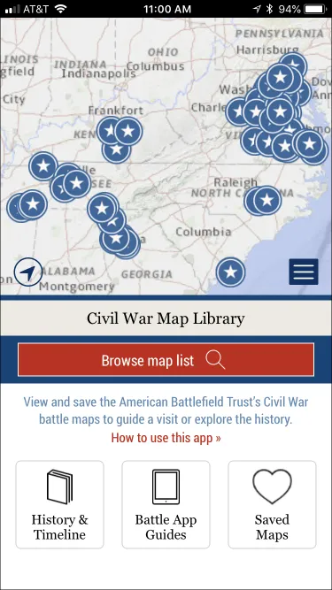
The Trust’s Civil War Battle Maps application includes more than 100 maps created by the Trust’s veteran cartographer, Steve Stanley, showing military maneuvers on the war’s best-known battlegrounds. Whether it’s Chickamauga, Shiloh, Appomattox or another hallowed Civil War site, each place was made famous by the momentous events that transpired on these now-tranquil landscapes.
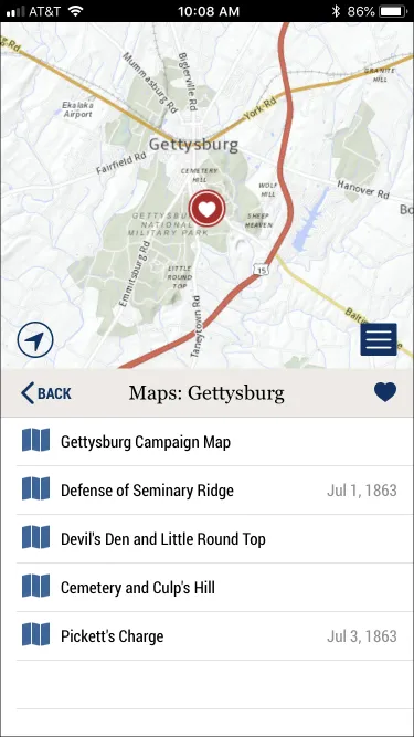
Developed for the Trust by Neotreks Inc. of Castle Rock, Colo., the GPS-enabled app empowers users to follow each battle’s action from the comfort of their living room, or while walking or hiking across historic ground. Its collection covers 83 battlefields in 142 maps, from Gettysburg in Pennsylvania to Glorieta Pass in New Mexico. More complex battles, such as Gettysburg, have multiple maps to explain the fighting as it unfolded across sometimes expansive terrain.
“This new digital resource is like having an atlas in your pocket, chock-full of detailed and well-researched maps of the nation’s most important Civil War battlefields,” Trust President James Lighthizer said. “The Battle Maps app helps people visualize where soldiers were and how they moved, orients visitors to the field, gives them a sense of the action, and links them to other resources to learn more. It’s a great tool to better understand these unique places and the momentous history that happened at them.”
“NeoTreks is proud to have had a hand in creating this mobile app to help people appreciate some of the most important and consequential battlefields of the Civil War, the defining conflict in our nation’s history,” said Michael E. Bullock, president & CEO of NeoTreks Inc. “We hope it entices more people to visit and learn more about these sacred sites and their unique qualities of historical moment, personalities and place.”
A one-stop shop for history enthusiasts, the Battle Maps app includes an overview of the 4-year-long war, timelines of each year of the fighting, and brief histories of 14 of the conflict’s major campaigns plus the Confederates’ 1862 excursion into Kentucky, as well as links to the Trust’s full suite of mobile Battle App guides. To date, titles in the Battle App series have been downloaded more than 670,000 times.
The latest in a robust series of mobile apps from the Trust, the Battle Maps app is available for free in iOS and Android versions from Apple’s App Store and Google Play. In addition to smartphones, it also works on iPads, the iPod Touch, and Android tablets. If the Trust has a multimedia Battle App for a particular battlefield, a link in the maps app takes users straight to it for a convenient download.
The Battle Maps app links mobile users to resources about its battles on the Trust’s website, where people can learn more about each engagement, and get information about visiting battlefield communities and related historic sites. For select battlefields, the web resources include videos, 360-degree Virtual Tours, Animated Maps, photo galleries, articles, and preservation opportunities. To aid visitors, the website includes 28 single- and multi-day travel itineraries for Civil War, Revolutionary War and War of 1812 battlefields.
Using GPS, the Battle Maps app places a moving blue dot wherever a smartphone user is on the ground at or near a battlefield, orienting them to their surroundings. Pinching and zooming the app’s base map will find a Civil War battlefield near the user or in specific geographic regions. Tapping the GPS button shows their location near or on that battlefield. Users can save maps to their phone for faster access, and to have them handy when they don’t have WiFi or good connectivity.
The Battle Maps app was created with support from the HTR Foundation of St. Petersburg, Fla.
All of the Trust’s Battle App guides can be found at battlefields.org/battleapps.
The American Battlefield Trust is dedicated to preserving America’s hallowed battlegrounds and educating the public about what happened there and why it matters today. The nonprofit, nonpartisan organization has protected more than 50,000 acres associated with the Revolutionary War, War of 1812, and Civil War. Learn more at battlefields.org.


