Fort Vincennes | Feb 23-25, 1779
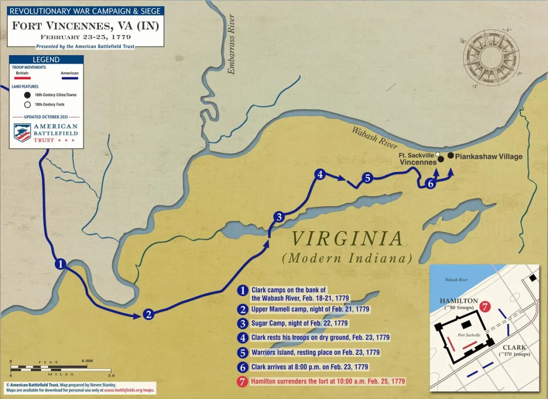
Fort Vincennes was located along the Wabash River, on the border of modern day Indiana and Illinois. Fort Vincennes was a timber fort in the town of Vincennes built by the British to guard the frontier ceded by France after the French and Indian War. British Lieutenant Governor Edward Abbott began construction in 1777. He was succeeded by Lieutenant Governor Henry Hamilton, who arrived in late 1778 with a force of 90 British Regulars and 200 Native allies. Hamilton was upset by the design and state of the fort, and immediately began work on strengthening the defenses. The fort was roughly square, with blockhouses on the northeast and southwest corners, a barracks, magazine, and gatehouse. The strongest parts of the fort were the blockhouses; made of thick timbers rendering them musket-proof, and mounting a three-pounder cannon each. By February of 1779 Hamilton had completed the major construction, but the stockades were still in a poor condition.
The Americans, fearing that every day delayed made Hamilton’s position stronger, decided to launch a winter attack on the fort. Stationed in Kaskaskia, about 180 miles west of the fort, was Lieutenant Colonel George Rogers Clark, older brother of William Clark of Lewis and Clark fame. Clark departed Kaskaskia on February 6, 1779 with 172 American and French militiamen. The 180 mile expedition proved to be extremely difficult, even by frontier standards. While the winter was not cold, it was exceedingly wet, forcing the men to endure wet conditions and wade through standing water in multiple places. By the time Clark arrived at Vincennes on February 23, food had also run dangerously low.
Clark entered the town at sunset. The local population, many of them French, was sympathetic to the American cause, and did not alert the fort or oppose Clark’s approach. Despite a large commotion, Hamilton did not realize he was under attack until the fort came under fire. Clark ordered a barricade built facing the fort’s gate, and both sides traded fire throughout the night. On the morning of the 24, Clark demanded Hamilton’s unconditional surrender, which was rejected, but Hamilton agreed to meet Clark to discuss terms.
In the interim, one of the most controversial and brutal episodes of the frontier wars occurred. A war party of natives and French-Canadians entered the town, unaware of the American occupation. After a short skirmish, Clark captured six and forced the rest to flee. Releasing the two French prisoners, Clark had the four Natives tomahawked to death in view of the fort and then scalped and thrown in the river. Clarke intended this to be both a deterrent and in revenge for the raids throughout the frontier; he never denied or apologized for the action.
At 10 am on February 25, Hamilton surrendered the fort, which the Americans renamed Patrick Henry. British losses were eleven killed and five wounded. The Americans suffered no losses in the attack; however five men were killed or wounded when a captured cannon that had been tampered with by the British exploded during a salute.
Related Battles
4
16


