Lessons from Pea Ridge

By Doug Scott and Steve Black
When the guns fell silent on the afternoon of March 8, 1862 and the spring rains started early, the battlefield of Pea Ridge began the slow return from killing ground to farmland. The objects of warfare that littered the landscape slowly started working their way into the soil, waiting for rediscovery. One hundred and forty years later that archaeological rediscovery began and today personnel at the battlefield that is now Pea Ridge National Military Park have gathered a treasure trove of information. But we are only now beginning to realize how much more work needs to be done.
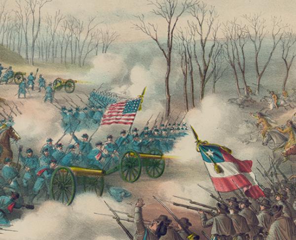
Pea Ridge National Military Park, located in the northwest corner of Arkansas, was the site of one of the most important battles in the trans-Mississippi theater. Fought over two days in March of 1862, this pivotal battle decided the fate of Missouri. The armies commanded by Major General Earl Van Dorn and Brigadier General Samuel R. Curtis locked in a desperate struggle for Missouri on the Ozark Plateau. When the firing stopped, Curtis’s Federals were in control of the field and Van Dorn’s Confederates were headed east to cross the Mississippi River, never to return to Arkansas.
War, time, and agricultural practices literally buried the physical evidence of that moment of history that National Park Service (NPS) archaeologists began to unearth in 2001. Over the years storms and plowing brought some items to the surface, that were found, picked up, sold in curio shops and makeshift museums about the battlefield. But there were still artifacts below the surface, waiting for advanced techniques to be used to locate them and for experts to help the artifacts to tell their tales. In 2001 NPS Midwest archaeological Center archaeologist Dr. Douglas Scott and a large team of volunteers began a three-year survey of the Pea Ridge Battlefield. Many things had happened in the intervening 140 years, including construction of a state highway through the battlefield and its subsequent removal when the area was transferred to the NPS. Agriculture, road building, and home construction disturbed some soil, but six inches to a foot below the surface there were thousands of artifacts still arrayed in their patterns of deposition waiting to be dug up to help the park staff and visitors gain a better understanding of the fight.
Despite the disturbances that have occurred due to farming and relic collecting on the Pea Ridge battlefield, the archaeological data recovered is the physical evidence of the momentous events on those cold days of March 1862. The archaeological record of the fights at Leetown, Clemon’s field, Elkhorn Tavern, and in Cox’s field provide a new and independent means of assessing and evaluating the disparate historical record of those events. It certainly does not alter the outcome, but it does provide a physical link and an interpretable body of data that park staff can employ to make important interpretive decisions such as proper placement of artillery pieces to illustrate battle lines at the site.
Analysis – through computerized modeling of the landscape and terrain – of the archaeological artifacts and their distribution provides the specific locations where troops and artillery batteries were positioned on the field. That evidence occurs in the form of impacted bullets and artillery shells, as well as lost equipment items and unfired bullets dropped or lost in the heat of battle. The archaeological evidence provides the tangible link with the historic accounts of precisely where actions occurred, and argues for a significant reinterpretation of the historic record of certain specific events during the last stages of the battle in Oberson’s field and Morgan’s woods near Leetown.

Archaeological discoveries of linear distributions of small arms bullets, both fired and lost, on the west side of Oberson’s field suggests that a 36th Illinois company was not aligned in line of battle from east to west line on the north side of the field, as previously thought, but rather that they were arrayed in an “L” shape on the north and west fence lines at the northwest corner of the field. In turn, their firefight with the 16th Arkansas was more intense than the historic documents and after action reports record.
Likewise archaeological recovery of canister balls at the northeast and southeast sides of Oberson’s field indicates that the opposing artillery were within canister range of one another, not firing blindly over a forested area as is often reported. This new information places the Confederate guns, probably Good’s and Hart’s batteries, on Foster’s lane near its juncture with the Leetown road. The finding of Confederate fired canister and the probable location of one or two batteries of Confederate artillery is new information that is not recorded in the historical record of the Leetown fight.
The discovery of three lines of impacted and lost or dropped bullets running north to south on the east side of Oberson’s field is the physical evidence of a desperate fight in that area that had only been hinted at in the after action reports and participant accounts. The fight in Morgan’s woods and on the eastern side of Oberson’s field is portrayed as a confused mêlée in the documentary record. The archaeological evidence, in contrast, suggests that Colonel Louis Hébert’s Confederate troops were more organized than previously thought and still had a good tactical organization when they nearly overran the position of the 2nd Illinois battery. Reanalysis of the historic record in light of the patterning evident in the archaeological data argues that, while the movement through Morgan’s woods was difficult and some men became disoriented, Hébert was still able to wheel his line to the south and attack the Union battery and its infantry support at the southeastern edge of Oberson’s field. Hébert also appears to have met a threat on his southern flank by refusing a portion of his line to the east creating an “L”-shaped line to meet his opponent’s own “L”-shaped line. The archaeological evidence shows the Union line gave way twice, with some evidence of tactical disintegration, but the third line, located some 200 yards west of the Leetown road, shows that command and control was regained, and the Union firepower overwhelmed the Confederate assault.
The archaeological evidence of artillery and small arms artifact distribution allows the identification of the likely locations of both Union and Confederate artillery batteries during the battle. The same scenario is also true of the small arms and artillery artifact distributions in Cox’s field associated with the fighting on the second day of the battle. The historic record of these elements of the fight, as well as the fight in Clemon’s field, is well documented from official reports and participant accounts from both sides. The archaeological record in this area confirms the accounts and enhances the record with physical evidence that provides a good deal more precision for on-the-ground interpretation of the specific elements of the battle. The archaeological record also confirms the terrific maelstrom of shot and shell that fell on the Confederate soldiers who were arrayed along the south face of Elkhorn Mountain. That archaeological evidence is a very poignant reminder of the shower of iron and lead that fell on those men. But that same archaeological evidence also shows that shot and shell alone did not dislodge the Confederates. It took a final infantry assault by the Union and a sharp firefight to push the Confederate rearguard out of their positions and off of the Pea Ridge Battlefield.
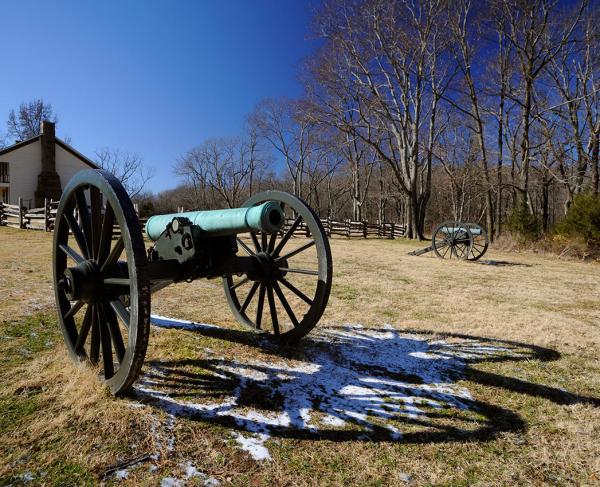
Coupling the archaeological data with historic accounts garnered a greater understanding of the events at a level of precision on the landscape that was not previously available. The park staff was able to place cannons in almost the exact spot they were in on March 7 on the Leetown Battlefield – in an area that had grown up into a forest. The park’s Resource Management staff cleared the area, and now the six cannons and howitzers of the 2nd Illinois Light Artillery are once again aimed across a recreated Oberson’s Cornfield into Morgan’s Woods awaiting the charge of the Colonel Hébert’s Arkansas and Louisiana troops.
The work continues to this day. In 2005, park staff placed cannons along Curtis’s final line of battle using information gathered from the archaeological investigations. The battlefield is taking on a whole new look as artillery pieces outline the historic lines of battle. Some vegetation is being thinned or removed to aid in recreating, as much as is possible, a landscape that resembles what the participants saw in 1862. Perhaps the greatest value of these investigations is not the artifacts that were found, nor even the interpretations of their patterning, rather it is the experience of having historians, archaeologists, natural resource managers, and park management working as a team to assess and reassess all the information to create a more accurate and better interpretive experience for the park visitor.
Learn More: Battlefield Archeology
Dr. Douglas D. Scott has been the Great Plains Team Leader for National Park Service’s Midwest archaeological Center in Lincoln, Nebraska since 1983. He specializes in nineteenth-century military sites archeology and forensic archeology and has written five books and more than 100 monographs and articles on those and related subjects. He is particularly noted for his expertise in battlefield archeology and firearms identification. Steve Black serves as Chief Ranger of Pea Ridge National Military Park. A sixteen-year veteran of the National Park Service, his background is nineteenth-century American military history. Originally from Virginia, he visited his first battlefield at the age of three and has been visiting or working at them ever since.
Related Battles
1,384
2,500